The Roman city of Urbs Salvia, in the Marche region, stretched along the slope of San Biagio hill to the bottom of the valley, reaching the Fiastra river which, 3-4 km from the archaeological site, flows into Chienti river. The Roman city, oriented north, in the flat part had the extra urban part with the amphitheater.
The current road, which flows through the archaeological park, 2000 years ago was a primary route: via Salaria Gallica. A branch of the main Salaria which from Ostia, through Rome and the Rieti, reached Ascoli where the Salaria Gallica branched, which, through the Sibillini Mountains, pointed true north towards Osimo and Jesi to reach Fossombrone, also a Roman municipality, where it crossed the via Flaminia that came out of the Furlo tunnel, 38 meters long (a wonderful engineering work for those times) built by the emperor Vespasiano.
Very important route that connected Ascoli with the north of the Marche, along the Via Salaria Gallica the remains of many buildings were found, even outside the city walls, such as the two tombs (still visible with the features of two towers) in the shape of a parallelepiped, which could reach 4-5 meters in height.
The walls, visible in the archaeological park, date back to the Roman pax period. The very thin wall was built in brick to demonstrate that, in that period, people lived in peace and therefore there was no need for powerful defense walls.
The area of the Forum was cut in two by the Salaria Gallica which, within the walls, constituted the cardo maximus. Certainly the most important building is the Temple of Salus Augusta, a hexastyle temple with Corinthian capitals and a central ramp with a platform that gave access to a lower portico, or cryptoporticus, which ran around the temple. To be venerated in this place of worship was the health of Augustus and his family: Urbisaglia was one of the first places where imperial political worship was introduced under Tiberius. The importance of the city of Urbs Salvia is also given by the fact that Salus Augusta was revered in only five cities throughout Italy: Terni, Gabi, Rome, Rimini and, in fact, Urbs Salvia.
The upper portico of the temple was equipped with a matroneum to allow devotees to attend the ceremonies while, in the rear part of the temple, there is a circular space, probably the place where religious ceremonies culminated and where the priests were arranged in a circle around an altar for sacrifices.
The south side of the cryptoporticus was excavated by the University of Macerata during the 1970s, thanks to the surveys made by aerial photos taken during the last world war. On that occasion, 140 meters of cryptoporticus, arranged on three sides, were brought to light.
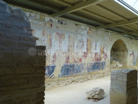
The cryptoporticus is admirably frescoed with elements celebrating Rome military power in the third Pompeian style, strongly geometric, which was in vogue in the first imperial era, from the age of Augustus to Claudius (27 BC – 50 AD). The pictorial apparatus presents, in the central panels, a series of beautiful weapons shown as trophies, recalling the widespread iconography of the triumphs. In the upper register violent and dynamic hunting scenes, hunting was one of the favorite shows of the Romans, here certainly a metaphor for a war situation that represents Rome victorious over its enemies. Moons with human traits probably refer to Diana, goddess of the hunt. Other frescoes, on the lower register, present beautiful masks with a refined technique, with various creatures such as satyrs, fauns, an owl, a goat, with an unknown function, perhaps decorative perhaps apotropaic.
Urbs Salvia’s wealth is also documented by the very extensive coinage found; especially the 1st century AD it was its heyday. The trade is also rich: many amphorae from Africa, Greece, Spain, the Middle East, 50 types of marble found suggest a very rich patriciate, so much so that, at the Archaeological Museum of Urbisaglia, precious statues are preserved, found in the site, made with Luni marble and Parian marble.
Benedetta Tintillini
Find the archaeological site of Urbs Salvia on Google Maps:


